Rural Highway 3052 runs along much of the northern edge of Khao Yai National Park serving as a shortcut between Thanarat (3077) Road to the west and Highway 304 in Wang Nam Khieo to the east. Over the past few years, this area has become a popular holiday destination, especially among well-to-do city slickers. However, not many of those tourists are aware that at the back of the many luxury resorts along the south side of the rural highway there's something which separates them from the protected forest that is home to numerous wildlife.
Running "secretly" in parallel with the 3052 but visible on Google Maps if you zoom in close enough, the so-called Khao Yai Fire Road not only serves as an effective firebreak and a clear and permanent marker of the park's boundary, it is also used as a patrol route by forest rangers and a cycling course by mountain bikers.
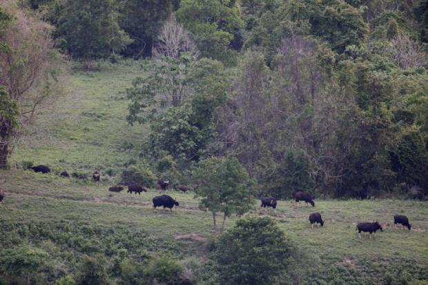
Hardy riders may begin their two-wheeled journey on this long dirt track from near the park's northern entrance (Pak Chong checkpoint) in Moo Si all the way to Khao Phaeng Ma, a foothill and a non-hunting zone adjacent to the northeastern corner of Khao Yai. Khao Phaeng Ma is well-known among nature lovers because it is a habitat of gaur and is one of the very few places where visitors have a good chance to spot the awesome wild cattle roaming freely in natural surroundings.
In case you may not have so much time or stamina, you can skip much of the fire road and start from the park's Klong Pla Kang Forest Protection Unit instead. The unit is not difficult to find because it is located near Ban San Kamphaeng Reservoir, which recently became famous on the internet because of the newly built scenic cycling path running along its edge.
From Klong Pla Kang, the distance may be a lot shorter but the ride condition is pretty much the same, minus fallen trees along the way. Also, it's a good idea to save some energy for the 2km final climb up Khao Phaeng Ma. Actually, apart from the lookout point near the hilltop, you may also spot gaur herds further down the hill along the fire road, especially in late afternoon. If you see the electronic fence put there to keep the wild animals within the safety of the protected forest, keep your eyes open and even better have a pair of binoculars at hand. The gaurs may not be far away. It's not every day that you get the chance to see such a majestic animal with your own eyes.

During our latest trip to Khao Phaeng Ma, my friends and I were extremely lucky. As we were slowly making our way down the hill after the sunlight became too low for shooting decent photos with a long telephoto lens, we spotted a dark mass on the roadside. It was moving, and with the species' signature "white socks" and the gold-coloured forehead between the horns, we knew right away it was a gaur.
We managed to capture a few photos of the lone bull before it disappeared into the forest. It was a magical moment I'll never, ever forget. I couldn't help but feeling thankful to everybody who helps protect our diminishing wilderness. I also hope that the bull will one day find a herd of its own.
Well, see you here again next Thursday. Until then, if you have questions, news or biking insights you wish to share, please feel free to send an email to pongpetm@bangkokpost.co.th or go to Freewheel Bangkok community page on Facebook.
Pongpet Mekloy is the Bangkok Post's travel editor and a mountain bike freak.
Moo Si - Khao Phaeng Ma (Khao Yai Fire road)
GPS co-ordinates:
Trailhead next to Monlada Resort:
14°30'58.00" N 101°24'17.61" E
Khlong Pla Kang Forest Protection Unit:
14°21'26.09" N 101° 43'28.29" E
Khao Phaeng Ma access road:
14°23'12.37" N 101°47'33.54" E
Trail condition: Double track with dirt surface.
Distance: Suppose you start from the resort, it's about 60km to the lookout point on Khao Phaeng Ma. If you begin your ride from Khlong Pla Kang, the distance is reduced to only about 17km.
Getting there: There are several points where the fire road can be reached but the three with GPS co-ordinates provided are the most convenient because they are close to Rural Highway 3052.
Parking: You can leave you car at the place you choose to start your bike ride from but that means you'll have to cycle back to fetch it. I recommend you have somebody drive the car for you to Khao Phaeng Ma or wherever you want to end your ride.
Food & drinks: There's no shop along the fire road but many on the 3052.
What your family can enjoy while waiting: They can chill out at one of the many restaurants along the 3052, and catch up with you later in the afternoon at Khao Phaeng Ma to watch the gaurs together.
Accommodation: You can camp on Khao Phaeng Ma but there are many resorts available along the northern boundary of the national park, especially in Wang Nam Khieo area.